What will I experience?
The POD approach is simple. Teachers must build their knowledge and skills in order to effectively teach with geospatial technologies. One way to do this is to experience learning with geospatial technologies. We help teachers use Esri’s ArcGIS Online, available to US schools and youth organizations for free through the ConnectEd initiative.
Teachers engage in a Geospatial Inquiry as learners. They do not learn the technology for the sake of learning the technology, but rather use the technology to enhance their abilities to find patterns and relationships in geospatial data for a purpose. Teachers use the technology to better understand important concepts and to communicate ideas about these relationships to others.
You engage in adult-level, Geospatial Inquiry with a focus on science. This serves as an example for you to create a similar Geospatial Inquiry for students in your specific content area.
You engage in a common Geospatial Inquiry experience as a learner:
- EXAMINE geospatial data
- ASK QUESTIONS about geospatial data
- ANALYZE AND INTERPRET geospatial data in ArcGIS Online
- ENGAGE IN ARGUMENT using geospatial data as EVIDENCE to support written arguments
- Present and receive feedback on your argument to peers in ArcGIS Online
- REVISE your argument based on peer feedback.
You practice 21st century skills:
- Think critically about geospatial data
- Use creativity to display patterns of geospatial data
- Communicate claims using geospatial data as evidence
- Collaborate with peers throughout the process
You reflect on your experiences:
- Consider to what extent these experiences affected your conceptual understanding
- Plan a similar learning experience for your students to enhance an existing lesson
You consider how Geospatial Inquiry can enhance student learning:
- Examine student work to consider implications for teaching and learning
- Become familiar with technology tools and resources that support Geospatial Inquiry
Why Geospatial Inquiry in the Classroom?
According to some estimates, up to 80% of the world’s data has a geospatial component to it. Demographics, watersheds, precipitation, temperature, real estate values, transportation routes—these are all examples of geospatial data. Critical issues facing our world including the environment, economy and security, depend on an understanding of geospatial relationships. Therefore, it is important for students build their capacity to reason with geospatial data.
Geospatial Inquiry engages students in geospatial thinking, which requires exploration of relationships and patterns in data. Because Geospatial Inquiry employs powerful geospatial technology tools, students are able to critically analyze authentic datasets in ways they would not be able to otherwise. When incorporated to support existing learning activities like research, field work, and laboratory investigations, Geospatial Inquiry can enhance student learning of disciplinary core ideas. The geospatial perspective can contextualize concepts in many subject areas to make them more relevant for students.
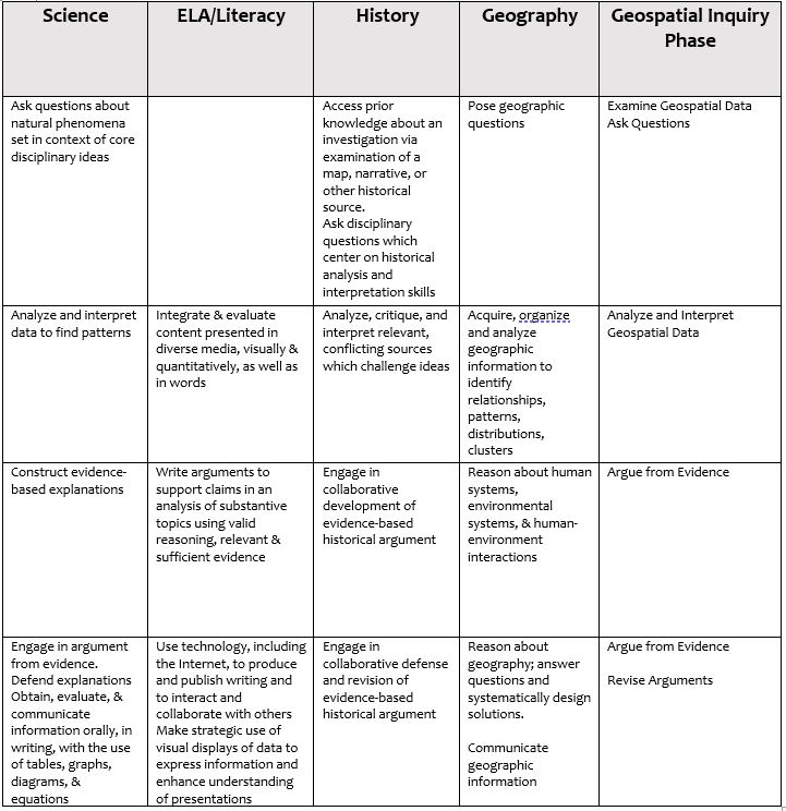
How does Geospatial Inquiry align with practices across disciplines?
Geospatial Inquiry enables students to engage in core practices in many disciplines including science, history, and geography. When students are equipped to take advantage of technologies that enhance their human capacities for spatial reasoning, like ArcGIS Online, they are better critical thinkers. They can evaluate the quality of geospatial data, uncover patterns and relationships, and act upon or make decisions based on these relationships. Geospatially literate students can use geospatial data as evidence to support written arguments, and consider the validity of arguments based on geospatial data.
What does Geospatial Inquiry look like in a classroom?
Science
Geospatial Inquiry could be used in an environmental science class to promote conceptual understanding of the Earth’s system and how changes to one part of the system affect the rest of it. After EXAMINING a map which shows the source of their fresh water, students can consider QUESTIONS such as:
- Does the source and amount of water available make any difference on how we use it?
- When we don’t see our source of water, how does this change our use of water?
- How does where we get our water and water our usage impact the region we live in?
Students can ANALYZE AND INTERPRET datasets on regional watersheds, local water and land use, global precipitation data, and population data to make a claim about these relationships and create visual representations of the relationships to support their written ARGUMENTS.
History
After EXAMINING a map, letters and historical photos of the aftermath of the 1906 San Francisco earthquake, students in a history course might ASK:
- What population was most affected by the disaster?
- Where was the most damage incurred?
- How long did it take the city to recover?
- Were certain populations more vulnerable than others?
In order to answer the questions, students can ANALYZE AND INTERPRET historical census data in comparison to the earthquake and infrastructure data to make a claim about these relationships and use the visual representations as EVIDENCE to support written ARGUMENTS.
What are the student benefits?
Teachers who attend POD Teacher Workshops enhance existing lessons through Geospatial Inquiry. Their students gain:
- Opportunities to engage in collaborative Geospatial Inquiry for a purpose: to answer a question, solve a problem, or explain phenomena.
- Exposure to exciting geospatial technology careers
- Employable skills:
- Critical thinking and data analysis
- Communicating with data
- Arguing from evidence and justifying claims
- Collaborating
- Presenting and responding to feedback
- Using Geographic Information Systems (GIS) technology