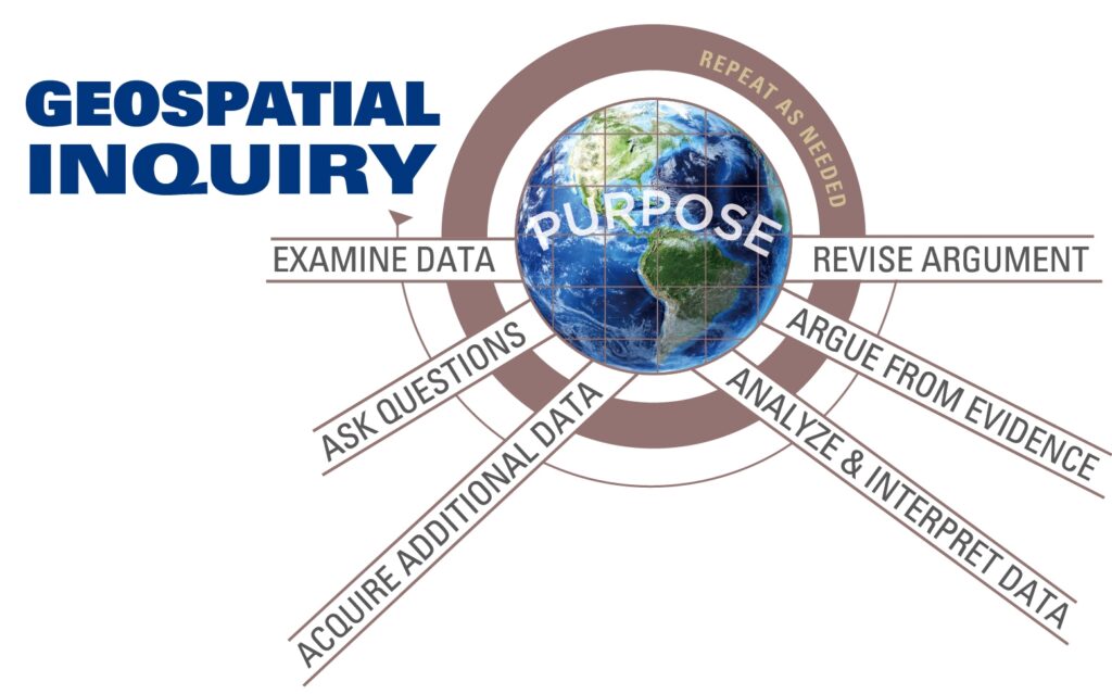
We define Geospatial Inquiry as:
Asking and answering a question through the analysis and communication of data that is linked to a geographic location on, above, or near Earth. These data are often represented visually via maps and explored with geospatial technologies such as ArcGIS Online.
Geospatial Inquiry involves analysis of geospatial data:
- Geo: of or pertaining to Earth
- Spatial: of or pertaining to space
- Data: facts and statistics collected together for reference or analysis
Geospatial Inquiry includes multiple phases, but it is a continual process and does not necessarily begin or end at any one point. Sometimes, a Geospatial Inquiry starts with a digital map that includes some points, lines and polygons, or “layers”. These layers are tied to a great deal of data, facts and statistics. Because they are tied to locations on Earth, these data can be displayed in a geographic information system (GIS), like ArcGIS online.
For example, perhaps we open a map that displays data from the Center for Disease Control. We see that each layer on the map is represented by points, lines, polygons, and/or images which represent features such as individuals who display symptoms of a disease, healthcare facilities, and roads and waterways. Because we are in an online environment, we can zoom, pan, and click around the map to EXAMINE GEOSPATIAL DATA. We begin to wonder why the features appear where they do. As we explore further and click on individual features on the map, we realize that each feature often has a lot more information associated with it than meets the eye. Some features have several attributes, or characteristics attached to them. For example, a point could represent a health clinic, but upon closer inspection, may include data about the total number patients treated within a certain time period, their ages, their symptoms, diagnoses, treatments and mortality rates. We can see this by displaying the attribute table that is associated with the feature. We begin to ASK QUESTIONS and look for patterns and relationships in the data. For example, we might wonder if there is a relationship between the occurrences of malaria and proximity to standing water. With a question in mind, we can begin to ANALYZE AND INTERPRET GEOSPATIAL DATA. We can filter the data to only display malaria cases. Then we can calculate how many instances of malaria occurred within a certain distance to a body of water. Armed with this information as evidence for our claim about this relationship, we are able to display the data for any intended audience, ARGUE FROM EVIDENCE, share our findings with stakeholders, receive feedback and REVISE our ARGUMENT as new evidence becomes available. At any given point along this geospatial inquiry, more QUESTIONS may arise, and we may need to ANALYZE AND INTERPRET additional GEOSPATIAL DATA in order to make an informed decision or better understand whatever we may be investigating.
Principles of Geospatial Inquiry
1. Geospatial Inquiry requires purpose: answering a question, solving a
problem, or explaining a phenomenon.
2. Geospatial Inquiry employs geospatial technologies as tools which
enhance the ability to make sense of relationships and patterns in
geospatial data and to create visual evidence to support written
arguments.
3. Geospatial Inquiry promotes cross-disciplinary practices and 21st
century skills such as collaborating with peers to ask questions,
creatively selecting and displaying appropriate geospatial data,
critically analyzing and interpreting geospatial data, and engaging in
argument using geospatial data as evidence to communicate ideas
to diverse audiences.
4. Geospatial Inquiry involves reflective practice. Learning
builds from prior knowledge and experience and requires
metacognition to support conceptual understanding.
5. Geospatial Inquiry is socially constructed. Learners require
opportunities to collaborate, compare ideas, and receive
feedback on those ideas through productive, equitable and
respectful discourse.
6. Geospatial Inquiry is iterative and sequenced over time and
employs technological and communication scaffolds to promote
conceptual understanding of big disciplinary ideas.
7. Engaging in Geospatial Inquiry and seeing how Geospatial Inquiry is
used by professionals provides inspiration to enter STEM careers.